
Land records
A Marlett Claim on the Mohawk River
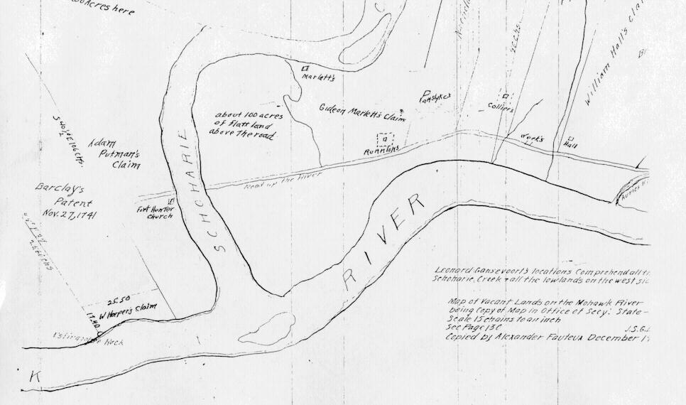
A copy of an old New York survey, the “Map of Vacant Lands on the Mohawk River,” marks a piece of land labeled “Gideon Marlett’s Claim.” Matched against a modern map, it can be placed almost exactly: beside Schoharie Creek, just west of Fort Hunter, in what is now Montgomery County, New York.
Reading the old survey
The survey is drawn upside down compared with a modern map: south is at the top. Three landmarks prove it. Schoharie Creek runs down from the top of the sheet into the Mohawk, and in fact the creek flows north into the river. “Fort Hunter Church,” which stood on the east side of the creek’s mouth, is drawn to the left of the creek. And “Auries Kil,” Auries Creek, which meets the Mohawk at Auriesville to the west, is at the right-hand edge.
Turned the right way up, Gideon Marlett’s claim lies on the south side of the Mohawk, just west of Schoharie Creek and south of the “Road up the river,” tucked inside a wide bend of the creek. Nearby the surveyor noted “about 100 acres of flatt land above the road,” a building marked “Marlett’s” up the creek, and a house site marked “Runnions.” The neighbors were Adam Putman across the creek, and Collier, Hall and William Hall to the west. Barclay’s Patent of 27 November 1741 lay beyond the creek to the east, and a note says that Leonard Gansevoort’s locations took in the lowlands on the west side of Schoharie Creek.
Where it is today
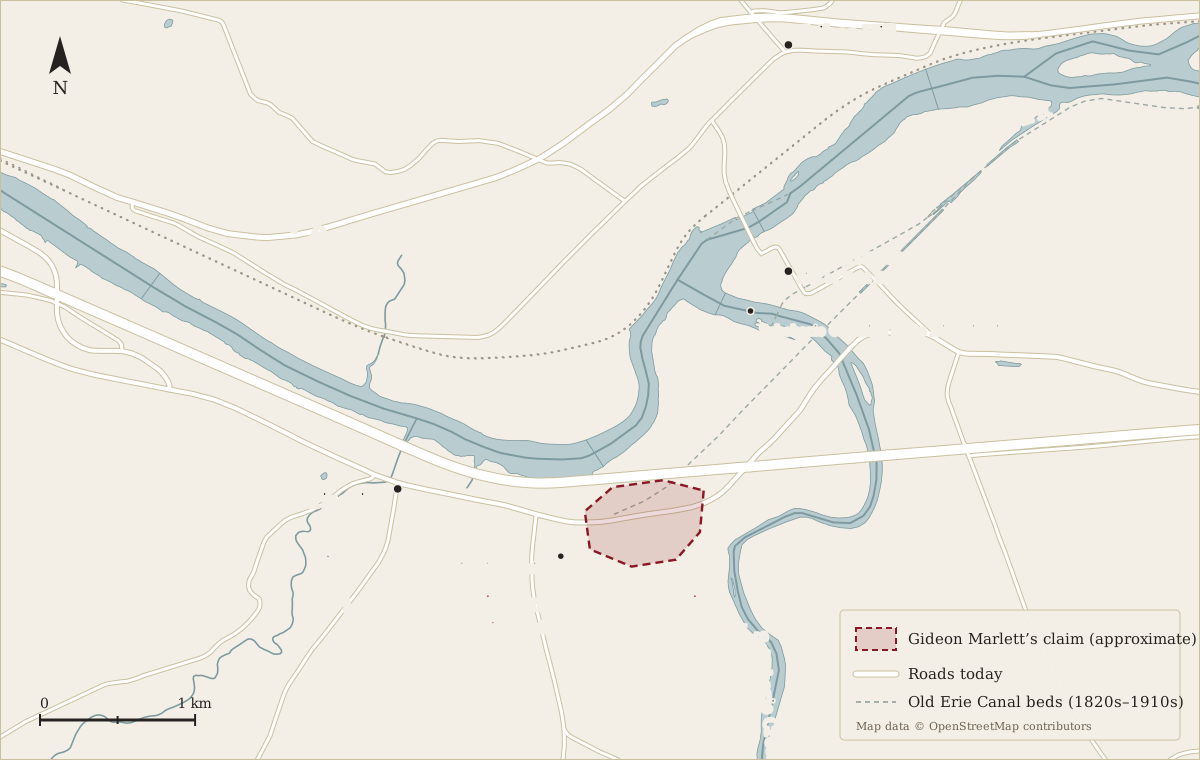
The claim was in what is now the Town of Glen, Montgomery County, New York, between the hamlets of Fort Hunter and Auriesville, about 20 miles west of Schenectady. The old “road up the river” followed much the same line as today’s Route 5S. Across the creek, the site of Fort Hunter and its chapel is now the Schoharie Crossing State Historic Site, and the Auriesville Shrine stands a short walk to the west.
In the 18th century this was frontier country. Fort Hunter was built by the British in 1712 beside the Mohawk town of Tiononderoge, with Queen Anne’s Chapel inside its walls, and the valley was being taken up by Dutch, German and English settlers holding land under large patents and smaller claims like this one.
Then and now: has the river moved?
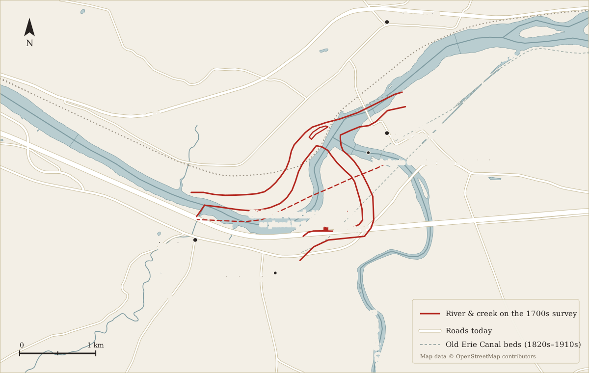
Laid over a modern map, the old survey and today’s river agree at the two creek mouths, as they must, but differ in between:
- The Mohawk’s course. On the survey the river runs from Auries Creek to Schoharie Creek in a gentle arc. Today it swings well to the south in a deep loop that almost reaches Route 5S. Some of the survey’s “road up the river” and flat land now lie under water.
- Schoharie Creek. The survey draws the last stretch of the creek a few hundred yards west of where it runs today, with its upstream bend swinging west rather than east.
- The island. The survey shows an island in the Mohawk just below the creek’s mouth. The river there looks quite different now.
Two things are at work. The first is that this is a hand-made copy of an old field sketch, not a modern survey, so some of the difference is simply the drawing. Bends and widths drawn by eye in the 1700s can easily be off by a few hundred feet, and a small error in the copy’s angle swings everything around the creek mouth.
The second is that the river really has changed, and this stretch has seen more change than most:
- Floods and a restless creek. Schoharie Creek drains the northern Catskills and is known for sudden, violent floods that scour its banks, move gravel bars and shift its channel near the mouth. The Mohawk, too, cuts and builds its banks in every major flood.
- The Erie Canal (1820s and 1840s). The first canal crossed Schoharie Creek here, and the enlarged canal of the 1840s carried boats over it on the stone Schoharie Aqueduct, whose arches still stand at Schoharie Crossing. Building the canal, its locks, feeder dams and embankments reshaped the flats on both sides of the creek.
- The Barge Canal (1917). When New York turned the Mohawk itself into a canal, it dredged the channel and built movable dams that hold the river up as a series of pools during the boating season. The river here is wider and deeper for much of the year than it was in Gideon’s time, and low flats along its banks were flooded or cut away.
- The New York State Thruway (1950s). The Thruway was built across these same flats, with a bridge over Schoharie Creek. In April 1987, floodwaters scoured away the ground beneath that bridge and part of it collapsed, a reminder of how hard the creek works on its banks.
So the land Gideon Marlett knew was a quieter river with broad flats between the water and the road. Much of the lowland the survey describes has since been dug, built over, flooded or washed away, which is one more reason the claim can only be placed approximately.
Which Gideon?
This cannot be the immigrant Gideon Merlet, who died on Staten Island in 1683; the survey mentions a patent of 1741, so it dates from the middle of the 1700s. Two later Gideons on this site are candidates:
- Gideon Marlett, born between 1694 and 1715, a son of Abraham Marlett and Elizabeth Morgan, who would have been a grown man with a family by the 1740s and 1750s.
- Gideon Marlett (1751–1820), recorded as born in Montgomery County, New York, which is this very area. He may be the claim-holder’s son, or the claim-holder himself later in life.
Either way, the survey is good evidence that a Marlett family was living on the Mohawk at Fort Hunter around the middle of the 18th century. It also casts doubt on the family tree’s record that the younger Gideon was the son of John Marlett of Mansfield Township, New Jersey. Finding the original survey and any land papers for the claim would help settle the question.
Finding out more
The original map was kept in the office of New York’s Secretary of State, whose colonial land papers are now in the New York State Archives in Albany. The claims on the Mohawk were often recorded in the Calendar of N.Y. Colonial Manuscripts, Indorsed Land Papers, which is where a petition or survey for Gideon Marlett’s land might be found.